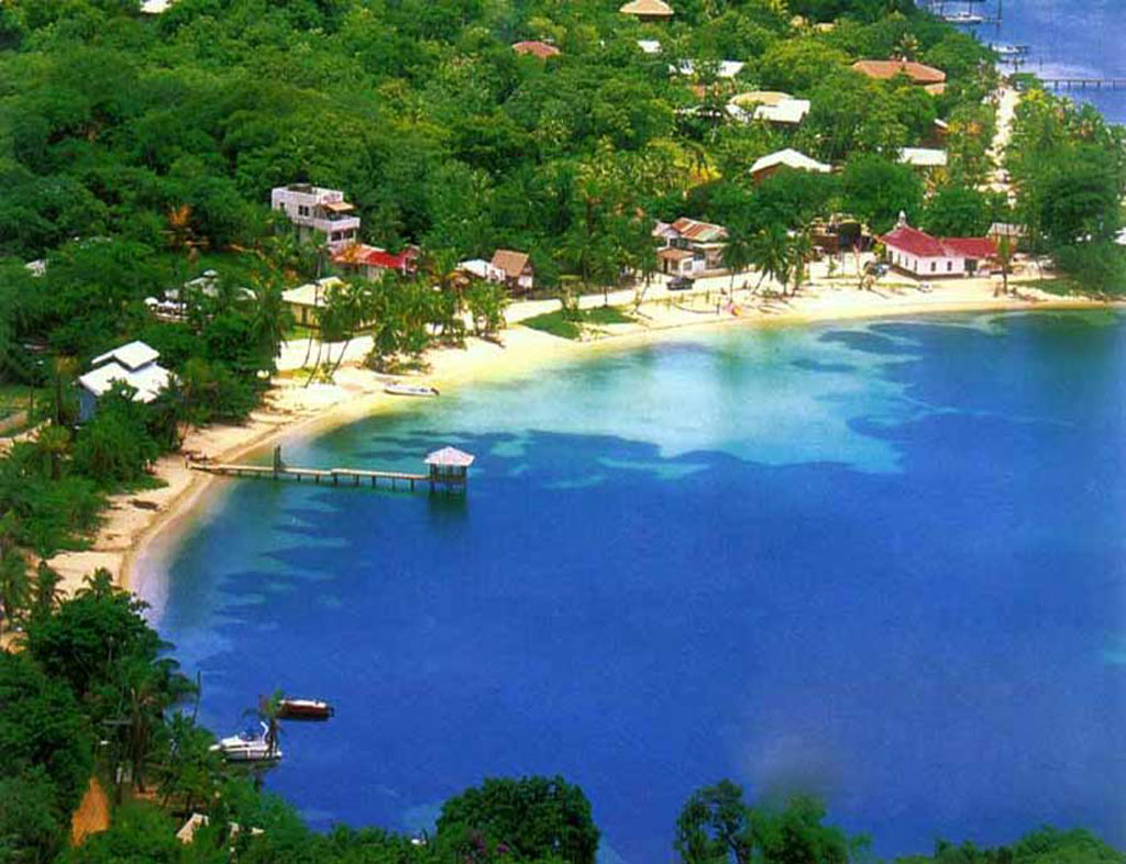
Presently the Honduras Bay Islands are primarily composed of three large islands, Utila, Guanaja, and Roatan, along with other smaller islands located off the coast of the mainland of Honduras. The islands are still very similar to the way they were when they were discovered over 500 years ago by Christopher Columbus. However, now that the islands are becoming a primary tourist attraction life on the islands has changed drastically. Population on the islands has risen drastically, and along with that came more tourist attractions, restaurants, and hotels.
It is hard to imagine that the Honduras Bay Islands could change too drastically in only 1,000 years. However there could very well be several changes. Unlike many islands, the Honduras Bay Islands do not feature any volcanoes, this rules out the possibility of volcanic activity having any impact on the islands in the next 1,000 years. It is a possibility that a substantial change in temperature could change the makeup of the island. A tropical climate, usually in the 80s and dropping no lower than the 60s, is featured on the islands essentially all year round. So if the temperature were to make a drastic rise or fall steadily or at some point in the next 1,000 years perhaps some plant life or species of animal on the island could no longer survive. Also, it is important to remember that continental drift could move the location of the islands slightly. Erosion could also cause the islands to experience minor physical changes.
A natural disaster could potentially have a major impact on the Honduras Bay Islands in the next 1,000 years. Currently, the islands along with their inhabitants are lucky enough to be located out of the hurricane belt as discussed earlier in the blog. However this does not completely rule out the possibility of a hurricane or another natural disaster striking the island at some point before the 3,000s, drastically changing the islands. For example a devastating hurricane could wipe out homes and developments, destroy plant and animal life, and even claim lives. Being tropical islands, the reconstruction process would not be as simple, and this could drive tourists away from the islands or stop cruise ships from making the islands a popular stop.
Technology is always rapidly advancing so it is nearly impossible to predict what life on the islands will be like in 1,000 years. On top of that none of us can know for sure what exactly our planet will be like in 1,000 years, compared to how long this planet has been in existence, 1,000 years is next to nothing, but at the same time a lot can happen in the length of time, especially with the way in which the world is rapidly advancing. Only time will tell the outcome of the Honduras Bay Islands in 1,000 years.
Thursday, December 6, 2012
Friday, October 26, 2012
Hydrology of Honduras Bay Islands
In order to keep its lush, green, environment, there must be plenty of water in and around the Honduras Bay Islands. Right off the bat, it is obvious that these islands are surrounded by water, as all islands are. The Caribbean Sea houses the islands of Honduras, and due to their location near the Mesoamerican Barrier Reef and outstanding diving opportunities, Roatan has become an important cruise ship destination. The Bay Islands feature many beautiful underwater caves that can be entered and explored on diving ventures. Personally, exploring these caves was a unique experience I will never forget.

La Ceiba, a port for the Bay Islands, is also a base for river trips in the Pinto Bonito National Park and Cangregal River. These mostly unexplored rivers offer extraordinary white water rafting opportunities and even feature a 600 ft waterfall, these rivers eventually have a final destination of the Caribbean. La Ceiba also offers fairies to take you for a ride on the Caribbean to the islands.
Recently the Bay Islands, primarily Roatan, have seen a large increase in population as well as tourism causing a major decrease in the availability of fresh water and natural resources and have also lead to deforestation and damages to marine environments. Due to this fact, Coxen Hole, the capital city, underwent construction between the years of 03 and 05 in order to add new black water, septic, and fresh water lines to accommodate the growing population. Many of these lines were not properly hooked up to the main sewage system causing sewage to run directly into the ocean. Residents were made to pay for the reconstruction of this project which began about a year ago in August 2011, however this is directly before rainy season on the Bay Islands begins. Rainy season begins in October and lasts through January, and features average rainfall of around 20 inches, topping at around 25 inches in December. In comparison to this, the summer months average around 5 inches. This being said, it would have been far more reasonable to do construction during the summer months, which became evident when rainfall washed clay and sediment that had been moved for construction into the ocean, damaging the beautiful reef. Despite this, the government and community are turning things around and heading in the right direction. This is a perfect example of the important of being aware of your surroundings. It is important to understand the rainfall the comes with the seasons and damage of the beautiful Caribbean Ocean could have been avoided.

Thursday, October 11, 2012
Climate and Weather of the Honduras Bay Islands
One of the primary reasons that the Honduras Bay Islands make for an excellent vacation spot is due to the fact that they feature an excellent climate. The average annual temperature is in the mid 80s, with highs of high 80s in the summer and lows of low 80s in the winter. Usually about three or four times a year, the occasional cold front, or norte, will sweep through the island, dropping temperatures into the 60s. Like the main land, humidity is high year round and is especially noticeable during the summer.
Average rainfall on the islands is around 100 inches per year. This creates a lush, green, and tropical environment. The islands feature a "Rainy Season"that usually ranges from October into January, with December typically featuring the highest amount of rainfall at about 24 inches. During the summer months weeks may go by without any rainfall, so when the islands do get a tropical downpour it makes for a welcome change. The temperature of the ocean around the islands makes for phenomenal swimming, diving, and snorkeling because the temperature is usually between 81-88 degrees Fahrenheit, a temperature so ideal that most of the time during the summer a body suit is not even required for SCUBA diving.
The islands experience a high degree of sunlight each year. This usually ranges from about eleven and a half to thirteen and a half hours a day due to the fact the islands are located near the equator. The warm climate due to being located near the equator causes hurricanes to be fairly likely during September and October. While these hurricanes rarely directly hit Honduras or the islands, even a far off hurricane can often cause an extreme amount of rainfall.
Sources:
http://www.aboututila.com/TouristInfo/Weather.htm
http://www.lonelyplanet.com/honduras/weather
 |
| waterviewproperties.com |
 |
| tropicaldiscovery.com |
Sources:
http://www.aboututila.com/TouristInfo/Weather.htm
http://www.lonelyplanet.com/honduras/weather
Wednesday, September 19, 2012
General geography of the Bay Islands
 The beautiful bay islands of Honduras consist of three islands, Utila, Guanaja, and located between them the largest of the three islands, measuring about 37 miles long, Roatan. The islands are fortunate enough to be geographically located out of the hurricane belt. Simply by looking at a map we can see that the islands are protected by the mainland of Honduras that sticks out of Central America acting as a shield protecting the islands. In the past 120 years only 7 hurricanes have passed by the islands. The bay islands of Honduras also contain no volcanoes.
Just as the mainland of Honduras is a very mountainous country, the bay islands feature tropical hillsides reaching up to 900 feet in elevation. The second biggest attraction to possibly only the incredible diving the islands offer are the beautiful white sandy beaches and deep harbors offering visitors outstanding fishing opportunities or simply a chance to relax and enjoy a relaxing, easygoing island vacation.

Possibly the most diverse population of coral occur around the bay islands of Honduras. In some areas the coral is so close to sea level that it is nearly impossibly to swim over it, not only that but this coral is located as close as 100 yards from the beach. The population of coral in this location is home to countless species of fascinating and vivid sea creatures. It is no wonder it is one of the premier snorkel and SCUBA sites on the planet. The geography of the bay islands is truly spectacular

Wednesday, August 29, 2012
Introduction to the Honduras Bay Islands
I'm Kenneth Tollefson, I'm 19 and a sophomore at UCD, studying to earn my business degree. I was born in Huntington Beach California and grew up there till the age of 14, before my family moved to the Denver area when my dad was transferred. It is safe to say the geography of Colorado is quite a bit different than that of California, but I enjoy spending time in both.
The location I chose for my "field trip" is the bay islands of Honduras. My mom is from Honduras so I have had the opportunity to visit the Central American country several times. Once for a school trip, and several other occasions to visit family members. When visiting family, my intermediate family would typically spend a week in Roatan, one member of the Honduran Bay Islands with some close friends of ours. Some of my fondest memories growing up took place in Roatan, from learning how to SCUBA dive, to zip lining, and just exploring the island and beaches in general. This, coupled with the fact that I'm sure it will be very interesting to explore scientifically is why I chose the bay islands of Honduras.
The location I chose for my "field trip" is the bay islands of Honduras. My mom is from Honduras so I have had the opportunity to visit the Central American country several times. Once for a school trip, and several other occasions to visit family members. When visiting family, my intermediate family would typically spend a week in Roatan, one member of the Honduran Bay Islands with some close friends of ours. Some of my fondest memories growing up took place in Roatan, from learning how to SCUBA dive, to zip lining, and just exploring the island and beaches in general. This, coupled with the fact that I'm sure it will be very interesting to explore scientifically is why I chose the bay islands of Honduras.
Subscribe to:
Posts (Atom)